The Shinano River does not merely flow; it dominates. Stretching 367 kilometers from the Japanese Alps to the Sea of Japan, it is the longest river in the country and the backbone of the Niigata rice basket. But for the millions living along its banks, its length is secondary to its power. Japan’s geography is defined by steep, volcanic terrain that turns even the most majestic rivers into high-speed chutes during the June rainy season or the autumn typhoon window. To rank these rivers by length is a simple geography lesson; to understand them is to witness a century-long struggle between an island nation’s need for water and its desperate fight against the mud and debris that come with it.
Japan’s "Class A" rivers are the lifelines of its economy, providing the irrigation for the world’s most expensive rice and the hydroelectric power that fueled the nation’s post-war miracle. Yet, these rivers are increasingly at the center of a climate crisis that is making historical flood-control models obsolete.
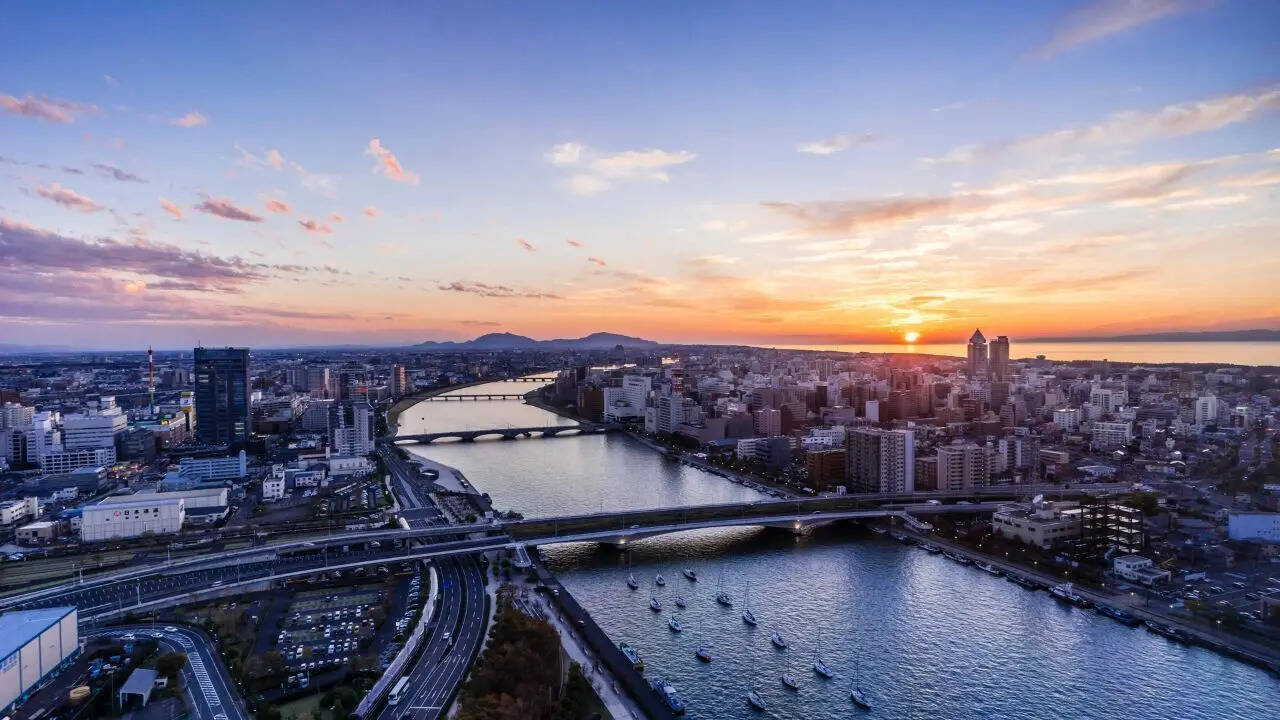
The Engineered Giant: Shinano River
While the Shinano (known as the Chikuma in Nagano Prefecture) holds the title for length, its true legacy is engineering. The river basin supports nearly three million people and some of the most productive agricultural land on earth. However, the very sediment that makes the Niigata plains so fertile is the river’s greatest weapon.
In the early 20th century, the Shinano was a frequent harbinger of destruction. The solution was the Ohkouzu Diversion Channel, an epic feat of civil engineering completed in 1922. By creating a literal "shortcut" to the sea, engineers successfully diverted floodwaters, effectively saving the Niigata city region from repeated inundation. This was not a one-time fix. Today, the river is a heavily monitored machine, balanced by dams and sensors that attempt to predict the unpredictable.
The Taming of the "Bando Taro"
Ranking second in length at 322 kilometers, the Tone River is arguably more critical to Japan’s survival than the Shinano. Nicknamed "Bando Taro" (the eldest son of the east), it was once a wild entity that flowed into Tokyo Bay. During the Edo period, the Tokugawa Shogunate undertook a massive project to shift the entire river mouth eastward to the Pacific Ocean.
This was not done for aesthetics. It was a strategic move to protect the capital from flooding and to open up new land for grain production. Modern Tokyo now relies on the Tone for nearly 80 percent of its industrial and drinking water. If the Tone fails, Tokyo stops. The river is currently reinforced by the Yagisawa Dam and a sophisticated network of underground discharge channels that look more like subterranean cathedrals than public works projects.
The Frozen Frontier: Ishikari and Teshio
In the northern reaches of Hokkaido, the Ishikari River (268 km) and the Teshio River (256 km) tell a different story. The Ishikari was once a meandering, chaotic snake that dominated the Ishikari Plain. To make the land habitable for the "pioneer" settlers of the Meiji era, the river was straightened. Over 29 cut-off channels were dug, shortening the river by nearly 60 kilometers to speed its flow to the sea.
The Teshio River, meanwhile, remains a rare anomaly. It is one of the few major rivers in Japan where the lower reaches remain largely free of massive dams. It is a glimpse into what Japan’s waterways looked like before the concrete era—a winding, slow-moving artery through dense forests and peat bogs.
The Ranking: Japan’s 10 Longest River Systems
While length is the primary metric for this list, the "Catchment Area"—the land that drains into the river—often determines its actual impact on Japanese life and disaster planning.
| Rank | River System | Length (km) | Primary Region | Key Feature |
|---|---|---|---|---|
| 1 | Shinano | 367 | Chubu | Longest in Japan; vital for rice production. |
| 2 | Tone | 322 | Kanto | Largest catchment area; Tokyo’s water lifeline. |
| 3 | Ishikari | 268 | Hokkaido | Heavily modified for agriculture and flood control. |
| 4 | Teshio | 256 | Hokkaido | One of the most "natural" flows remaining. |
| 5 | Kitakami | 249 | Tohoku | Historically used for transporting salt and rice. |
| 6 | Abukuma | 239 | Tohoku | Flows through the heart of Fukushima and Miyagi. |
| 7 | Mogami | 229 | Tohoku | Famous for its rapid currents and cultural history. |
| 8 | Tenryu | 213 | Chubu | Known as the "Violent Tenryu" due to its flow speed. |
| 9 | Agano | 210 | Chubu/Tohoku | High discharge volume; critical for hydro-power. |
| 10 | Shimanto | 196 | Shikoku | The "Last Clear Stream" with no major dams. |
The "Violent" Tenryu and the Hydroelectric Push
The Tenryu River (213 km) earns its reputation through sheer velocity. Dropping from Lake Suwa through the "Tenryu Kyo" gorge, it is a powerhouse of kinetic energy. Japan’s lack of fossil fuels historically forced a pivot toward this "white coal." The Tenryu is stepped with dams that provide electricity to the industrial hubs of Shizuoka and Aichi.
But this power comes at a cost. The dams trap sediment that should naturally replenish Japan’s coastline. As a result, many beaches in the Enshu-nada region are disappearing. The river is no longer just water; it is a complex management problem involving coastal erosion, energy needs, and the constant threat of a "once-in-a-century" storm.
The Clear Stream Exception
The Shimanto River in Kochi Prefecture is the outlier on this list. At 196 kilometers, it barely makes the top ten, but it is perhaps the most famous river in modern Japanese culture. It is frequently cited as the "last clear stream" because it lacks large-scale dams on its main stem.
Instead of concrete barriers, the Shimanto features Chika-hashi (sinking bridges). These are low, rail-less bridges designed to be submerged during floods, allowing debris to pass over them rather than snagging and destroying the structure. It is a philosophy of submission rather than dominance—a rare echo of how Japan managed its waters in the centuries before the industrial revolution.
The Shift Toward "Room for the River"
The 20th-century approach was simple: build higher levees and more concrete. This worked for decades, but climate data from the mid-2020s suggests the limits have been reached. When a levee breaks today, the "levee effect"—where people build in high-risk areas because they feel safe—results in catastrophic damage.
We are seeing a quiet pivot in Japanese policy. Instead of just containing the water, the Ministry of Land, Infrastructure, Transport and Tourism (MLIT) is beginning to experiment with "retarding basins"—designated zones, often farmland or parks, that are intentionally allowed to flood to take the pressure off downstream cities.
It is a return to a more ancient wisdom. In the Edo period, "Shingen-tsutsumi" (embankments designed by Takeda Shingen) utilized the natural topography to bleed off flood energy. We are finding that the most advanced technology might just be knowing when to let the river win.
The Infrastructure Debt
The maintenance of these ten arteries is an staggering financial burden. Much of the concrete infrastructure installed during the 1960s and 70s is reaching the end of its design life. Cracks in dams, silted-up reservoirs, and crumbling levee walls require billions in annual investment.
The Agano River (210 km) serves as a cautionary tale for those who view rivers only as industrial tools. Historically, it was the site of the Niigata Minamata disease, where industrial runoff poisoned the ecosystem. Today, the water is clean, but the memory remains a reminder that a river is a living system, not a plumbing fixture.
The Future Flow
As urban populations in Tokyo and Osaka continue to densify, the pressure on the Tone and Yodo river systems will only increase. We are no longer in an era where we can simply "build our way out" of the water problem. The rivers are getting warmer, the snowmelt is coming earlier, and the typhoons are carrying more moisture.
The ten longest rivers in Japan are more than just statistics on a map. They are the frontline of a national adaptation strategy. Whether it is the industrial might of the Shinano or the stubborn clarity of the Shimanto, these waterways define the limits of Japanese life. The next decade will not be about who can build the highest wall, but who can best listen to the rhythm of the water.
The era of total river dominance is over.