Spring across the American heartland isn't just about blooming flowers and longer days. It's the start of a volatile atmospheric battleground. Every year, we see the same headlines warning that the Plains and the Midwest are bracing for severe weather and possible tornadoes. Yet, despite decades of advanced radar technology and endless emergency drills, these storm systems still catch communities off guard.
The real issue isn't a lack of data. It's complacency and a fundamental misunderstanding of how modern severe weather setups evolve. When a massive low-pressure system pulls warm, moist air from the Gulf of Mexico and collides with cold, dry air dropping down from Canada, the result is a recipe for atmospheric chaos.
If you live in these high-risk zones, relying on a sirens-and-hope strategy will eventually fail you. Understanding the mechanics of these volatile weather patterns and knowing how to interpret shifting forecast models can mean the difference between staying safe and becoming a statistic.
The Atmospheric Collision Driving Central US Storms
The geography of central North America makes it uniquely susceptible to extreme weather. There are no major mountain ranges running east to west to block contrasting air masses from slamming into each other. This creates a highly volatile zone where severe storms can rapidly intensify over just a few hours.
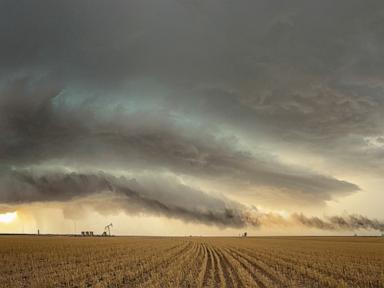
Three specific ingredients must come together simultaneously to trigger a major tornado outbreak.
First, you need low-level moisture. The Gulf of Mexico acts as a giant boiler room, sending humid air north across Texas, Oklahoma, and Kansas. Second, you need instability. When the sun heats the ground, it warms this moist air mass from below. This warm air wants to rise rapidly because it's lighter than the cold air sitting high above it in the atmosphere.
The final, critical component is wind shear. This happens when wind speed or direction changes rapidly with altitude. If winds near the ground are blowing out of the southeast at 15 miles per hour, but winds a few thousand feet up are howling out of the west at 60 miles per hour, that air column starts to spin horizontally. An intense updraft can tilt this spinning air vertically, transforming a standard thunderstorm into a rotating supercell.
Why Standard Severe Weather Forecasts Fail Consumers
Most people check their phone weather app, see a cartoon thunderstorm icon, and assume they'll face a rainy afternoon. That's a dangerous mistake. Standard apps completely flatten the nuance of complex meteorological data. They don't tell you if a storm is a generic heavy downpour or a tornadic supercell capable of throwing softball-sized hail.
Meteorologists at the Storm Prediction Center (SPC) use a five-tier convective outlook system to rate severe weather risks. It runs from Marginal (Level 1) to High (Level 5). The problem is that many people ignore anything below a Level 3 (Enhanced) risk.
History shows that significant, destructive tornadoes can and do occur in Level 2 (Slight) risk zones. Weather systems are dynamic. A slight shift in a dryline—the boundary separating moist and dry air masses—can push the core threat zone fifty miles east or west of the morning forecast. If you aren't tracking the actual atmospheric ingredients as they develop throughout the day, you're looking at outdated information.
The Myth of the Safe Room and Other Structural Failures
Many homeowners across the Plains and Midwest harbor a false sense of security about their houses. They think having a brick facade or a sturdy interior closet guarantees survival during an EF3 or stronger tornado. It doesn't.
Standard residential construction in the United States focuses on vertical loads, meaning the structure is built to hold up the weight of the roof and floors. Tornadoes generate immense lateral (horizontal) wind loads and intense aerodynamic lift. When high winds get under a standard roof overhang, they can lift the entire roof structure off the walls. Once the roof goes, the exterior walls lose their structural support and collapse outward.
True safety requires an engineered anchor system. Unless your home features heavy-duty hurricane ties connecting the roof trusses to the wall studs, and those studs are securely bolted directly to a concrete foundation, your house can disintegrate from the top down in under thirty seconds.
If you don't have a dedicated underground storm cellar or a reinforced concrete safe room built to FEMA P-361 standards, your best option is an interior, windowless room on the lowest floor. But let's be honest about what that is. It's a last resort, not a guarantee.
Immediate Steps to Up Grade Your Storm Survival Strategy
Stop relying on outdoor tornado sirens as your primary warning system. Sirens are decades-old technology designed exclusively to warn people who are already outside. They were never intended to wake you up inside a insulated house in the middle of the night.
To actually protect yourself and your family when severe weather threatens the Plains or Midwest, implement these steps right away.
- Buy a dedicated NOAA weather radio. Choose a model with Specific Area Message Encoding (SAME). This allows you to program the radio to only alarm for your specific county, preventing false alarms from storms sixty miles away while ensuring you get loud, immediate alerts if a tornado warning is issued for your neighborhood at 3 AM.
- Identify your precise shelter spot today. Clean out that interior closet or basement corner now. Don't wait until the skies turn green to realize your safest space is crammed full of old holiday decorations and heavy boxes. Keep a pair of sturdy shoes, a flashlight, and a whistle in that shelter space permanently.
- Download a radar app that shows velocity data. Apps like RadarScope or RadarOmega show you what the storm is actually doing, not just where it's raining. Learn to look for a "velocity couplet," where winds moving toward the radar site sit directly adjacent to winds moving away from it. That's a clear sign of rotation, often appearing on radar several minutes before a formal tornado warning is issued.
- Protect your head above all else. The vast majority of tornado-related injuries and fatalities are caused by flying debris. Keep bicycle or motorcycle helmets in your designated shelter area. Putting a helmet on your kids when a warning is active is the single most effective way to prevent severe trauma from falling drywall or airborne objects.
The atmosphere across the central United States is growing more volatile, and storm systems are moving faster than ever. Stop treating severe weather watches like a minor inconvenience. Track the atmospheric setups, upgrade your alert systems, and have a concrete, actionable plan ready before the sirens start blowing.